On this page
About the project
The City of Guelph completed a land use study and urban design concept plan for the York Road/ Elizabeth Street area. Land use refers to the purpose the land serves, for example, residential, commercial, recreational or industrial.
The land use study was approved by Council on May 10, 2021, and the urban design concept plans were approved by Council on May 9, 2022.
Read the approved land use study
Read the approved Urban Design Concept Plans
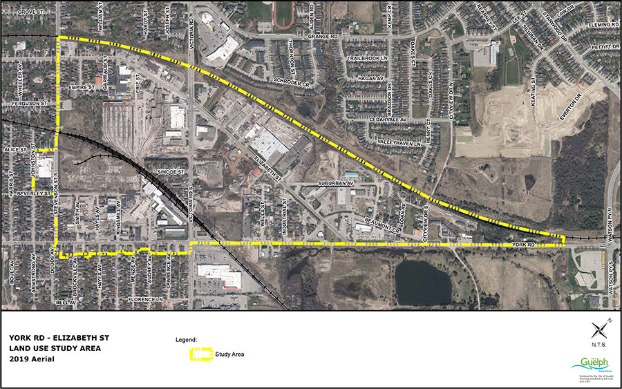
The study area runs along York Road from Stevenson Street South—captures part of Johnson Street—to Watson Parkway south and is bound by the Metrolinx/CN rail line to the north. The plan area also includes the south side of York Road between Stevenson Street and Victoria Road as shown in the map below.
Latest updates
200 Beverley Street
While the former IMICo lands, located at 200 Beverley Street, are within the study area boundary, the Council-approved vision for these lands will not be re-examined as part of this study. Learn more about the 200 Beverley Street lands.
Project timeline
- September 2020: Background report released
- Late 2020: Community engagement
- Early 2021: Draft land use study and additional community engagement
- May 2021: Land use study approved by Council
- January/February 2022: Community engagement on the draft urban design concepts
- May 2022: Urban design concepts approved by Council
Community engagement
Opportunities to have your say have closed.
We received your feedback in September 2020, February 2021 and January 2022. Results are available to view below.
Phase 1 Community Engagement Summary – October 30, 2020
Phase 2 Community Engagement Summary – March 25, 2021
Background materials
Learn more about the project by reading the background report. These materials outline the history of the area and its current development including opportunities and challenges for future planning in the area.
For more information
Planning, Building, Engineering and Environment
519-837-5616
[email protected]

