On this page
What Is a Subwatershed Study?
Subwatershed planning is a multidisciplinary approach for managing natural heritage and water resources that is based on ecology, engineering, land use planning and resource management. Protection, maintenance and restoration of natural heritage, water resources and their functions are integral to subwatershed planning. Subwatershed plans are implemented through the policies of Guelph’s Official Plan and supporting master plans, such as the Stormwater Management Master Plan.
Subwatershed studies include:
- characterization of existing conditions
- assessment of impacts, and
- identification of implementation and management recommendations
About the Study Update
The City of Guelph is conducting a study update for the Clythe Creek subwatershed previously completed in 1998. Since this time, major land use change has occurred in much of the subwatershed, and new insights are required to best evaluate impacts of proposed development plans and protect our natural resources.
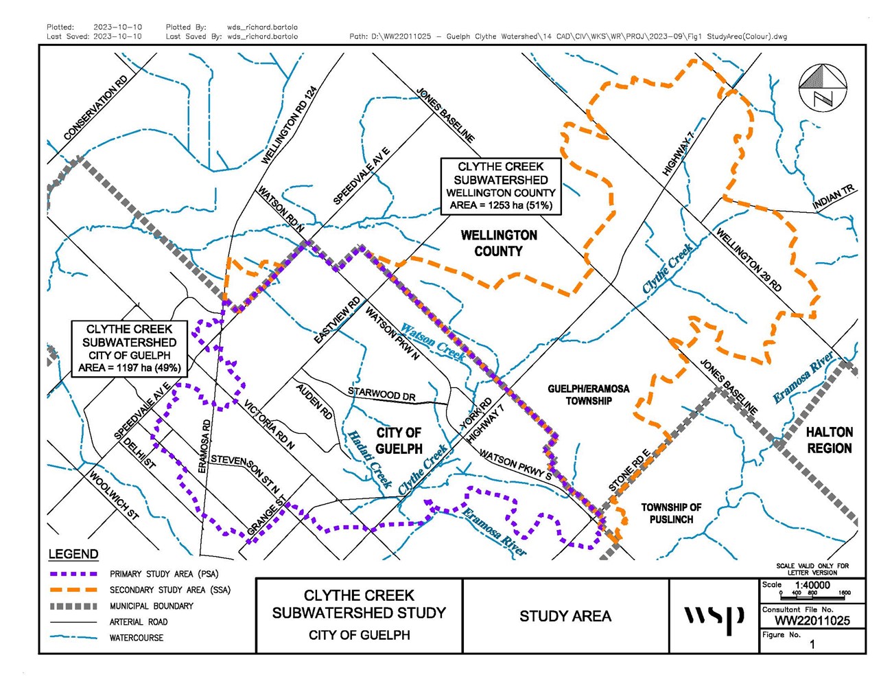
The Clythe Creek subwatershed drains to the Eramosa River located inside the Grand River watershed. It includes Clythe, Hadati and Watson Creeks and is on the east side of Guelph and Guelph/Eramosa Township in Wellington County.
In 2018, Council approved the City of Guelph’s Natural Heritage Action Plan and directed staff to undertake the identified actions, which included a background review and gap analysis of existing subwatershed studies (Action 1) and a framework for undertaking and prioritizing subwatershed studies (Action 2). Actions 1 and 2 were completed in 2021 and the Clythe Creek subwatershed study update was identified as the highest priority.
Community Engagement
We encourage the community to follow and get involved with this project. Please visit the engagement page to watch recordings of public open houses, review feedback from the completed engagement process, and learn about future opportunities to provide feedback.
Project Phases
Phase 1: Subwatershed Characterization (2022 to 2025)
We will review and assess existing background information; complete field work to better understand surface water, groundwater and natural heritage features and functions; review the existing policy framework in the area; refine the subwatershed boundary; update floodplain hazard mapping; and characterize and assess existing conditions. Phase 1 will include community engagement to help the project team further understand the community’s experience and observations of the area to inform the characterization and assessment of existing conditions.
Phase 2/3: Impact Assessment and Management (2025-2026)
Using the information compiled in Phase 1, Phase 2 will model impacts to surface water, groundwater and natural heritage features and functions based on anticipated land use changes. Three different land use scenarios will be modelled. The impact analysis will focus on the portion of the subwatershed that is in Guelph (Figure 1, Primary Study Area) and will consider the portion of the subwatershed that is in Guelph/Eramosa Township (Figure 1, Secondary Study Area). Following the impact assessment, we will identify management approaches to mitigate anticipated impacts and improve existing conditions. An implementation plan will be developed to identify priorities. A monitoring program will be established to evaluate the effectiveness of management practices and enable adaptive management to continually improve and learn from the outcomes of implemented management practices. Phase 2/3 will include community engagement to receive comments on management recommendations.
Documents
- Clythe Creek Subwatershed Study – Phase 1 Overview
- Clythe Creek Subwatershed Study Update Draft Phase 1 Characterization Report
- Natural Heritage Action Plan
- Clythe Creek Subwatershed Study Overview – 1998
For More Information
Leah Lefler
Environmental Planner
Planning Services
519-837-5616 extension 2362
[email protected]