On this page
About this project
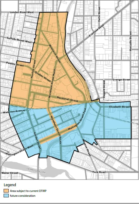
The purpose of the Downtown Infrastructure Renewal Program is to improve and upgrade roads, sewers, watermains, sidewalks, cycling facilities, and the streetscape within the areas designated within the Downtown Secondary Plan. The work is limited to the portion north of the Metrolinx railway tracks plus Wyndham Street South to Wellington Street and Wellington Street from Gordon Street to Neeve Street.
Delivery of this scope will be enhanced through additional activities to ensure alignment with the Downtown Coordination Plan and Communication Framework.
We have a great downtown and want to make it even more resilient, attractive, and welcoming for everyone of all abilities and ages using all modes of travel.
Work like this doesn’t happen overnight. It takes years to study, engage with the community, plan for and implement a generational renewal of municipal downtown infrastructure. That means construction and related disruptions, and we’re committed to phasing and carrying out this work in a way that minimizes the impacts to people living in, working in, and visiting Downtown Guelph.
We’ll be engaging with the public on the pace of construction in spring 2024, with construction expected to begin in 2026. As we rebuild roads, we’ll also be modernizing the streetscape. With intentional and responsible planning, the infrastructure we build today will create the foundation for prosperity, sustainability, and well-being for half a century or longer.
We’re committed to working with the Downtown community to plan and schedule this work in a way that limits the impact to daily life as much as possible. Together, we’ll create innovative solutions to keep our historic core thriving during construction.
This project is part of the overall Downtown Renewal Program to revitalize and transform Downtown Guelph for even more prosperity and well-being.
Study area
The primary study area is north of the railway tracks that cross Gordon Street at Waterloo Avenue. Key streets include:
- Baker Street from Quebec Street to Woolwich Street
- Quebec Street from Wyndham Street North to Norfolk Street
- Wyndham Street from Carden Street to Woolwich Street
- Macdonell Street from Norfolk Street to Carden Street
- Woolwich Street from Macdonell Street to Norfolk Street
- Macdonell Street and Allan’s Dam structures over the Speed River
Timelines
- Preparatory stage: Q2 2021 to Q1 2022
- Review existing conditions and develop problems and opportunities: Q2 to Q3 2022
- Develop alternatives to address the problems and opportunities: Q4 2022 to Q1 2024
- Develop study recommendations: Q2 to Q4 2024
- Prepare project documentation: Q2 to Q4 2024
Project status and last quarter update
![]()
Within revised scope
![]()
On revised schedule
![]()
Within revised budget
- In Q4 2023, staff advanced the two environmental assessments and the Capital Implementation Plan.
- Staff reviewed community feedback from September 2023 public information centre and Have-Your-Say engagement on the short-listed options for the Wyndham corridor environmental assessment. The recommended preferred solution will be presented to Council in February 2024.
- Community engagement and consultation will continue and be enhanced for the overall Capital Implementation Plan during 2024
- A Council Workshop will be held in May 2024 to present streetscape options for downtown along with construction pacing and mitigation.
- Background studies and preparations are underway for Macdonell and Allan structure environmental assessment engagement in Q2/Q3 2024.
- The various deliverables will be finalized in 2024.
Latest updates
Community engagement
Community engagement has and will continue to be a very important part of this project. Since launching in 2021, we’ve held many online and in-person events to:
- introduce the work,
- set the context for the environmental assessments,
- present and validate problem and opportunity statements, and
- answer questions and address concerns about the project and impacts.
The project team is now planning the phasing of how construction will unfold and seeking community input on the pace of construction and construction impacts at the March 27, 2024, open house. We will continue to have opportunities for the community to share their thoughts as the project advances.
Visit Have Your Say to learn more about past, current and upcoming engagement activities to share your feedback with us.
Capital Implementation Plan and environmental assessments
As part of this program of work, the City is undertaking a Class Environmental Assessment (EA) for the Macdonell Street bridge and Allans Dams structures and completed an EA process for Wyndham Street (initiated as an EA; now exempt). The City is now developing an overall Capital Implementation Plan for this work.
EAs include technical studies and engagement with community to support decision-making for large projects. The EAs are being completed in accordance with the Municipal Class Environmental Assessment process as described in the Environmental Assessment Act. The EAs for this program of work will inform decisions about how the work gets done and what’s included.
- Wyndham Street EA: this project was initiated as a Schedule “B” Municipal Class EA in January 2021, and is now being completed as an EA-exempt project in accordance with the Municipal Class EA (October 2000, amended in 2007, 2011, 2015). The project reviews the function of Wyndham Street North for all users to determine how the road should be redesigned including the number of traffic lanes, active transportation options, and the layout of the Wyndham Street and Quebec Street intersection (St. George’s Square).
- Macdonell Street bridge and Allans Dam structures EA: this EA will confirm what improvements are needed to address structural deficiencies and improve road safety for the required improvements and the preferred solution for the Macdonell Street bridge, the Allans Dam bridge, the Allans Dam spillway and sluiceway.
The City presented the preferred option for the Wyndham Street EA to Council in February 2024, and expects to present the preferred option for the Macdonell and Allans structures EA to Council in 2025. Once the EAs are completed and have been approved by the Province, phasing and staging will be determined through the development of the Capital Implementation Plan in 2024.
Resources
- Downtown servicing study: final report 2021
- Downtown servicing study:_Appendix 2021
- Downtown Guelph project: August 9, 2021 virtual presentation
- 2014 Streetscape Manual
Additional project details
- Executive sponsors: Jayne Holmes, Deputy Chief Administrative Officer, Infrastructure, Development and Enterprise Services
- Program manager: Reg Russwurm, Manager, Design and Construction, Engineering and Transportation Services
- Approved budget: 2,846,218 (planning phase only)
- Funding sources: 53 per cent grants and subsidies, 25 per cent tax reserves, 22 per cent rate reserves
- Target completion (planning phase only): Q4 2024
For more information
Reg Russwurm, Manager, Design and Construction
Engineering and Transportation Services
City of Guelph
519-822-1260 extension 2765
[email protected]